Natural Hazards
Forecasting and detecting hazards before they become disasters — urban land subsidence, landfill leachate and wildfire risk.
- R² > 0.90
- Model Accuracy
- ~55%
- Error Reduction
- −111 mm
- Max Subsidence Detected
- 30×
- Faster Inference
R² on held-out city test sets
vs. standard LSTM baselines
Annual deformation in monitored cities
Compared to numerical simulators
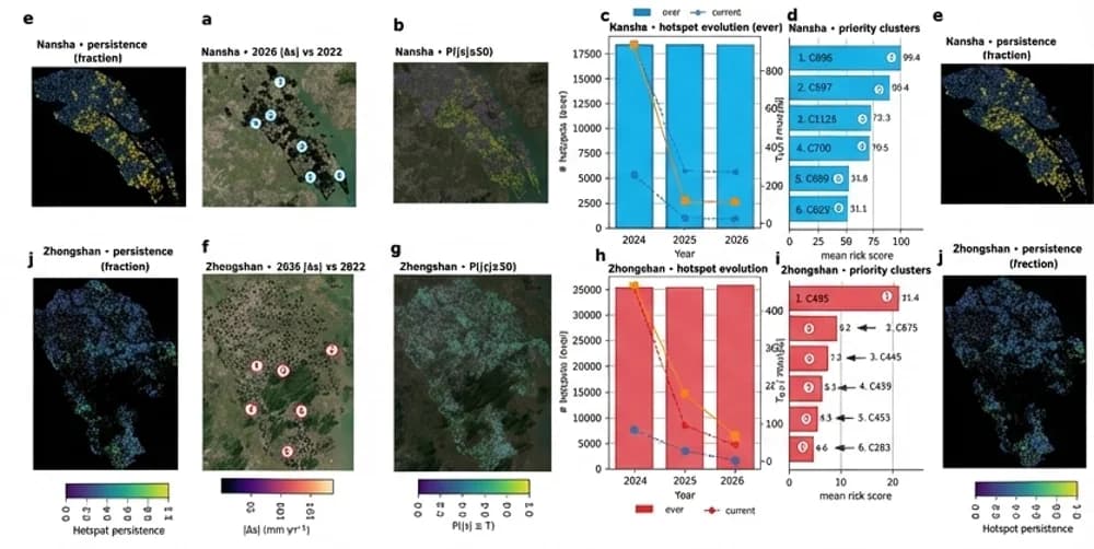
Urban land subsidence
Physics-guided forecasting with GeoPriorSubsNet, from InSAR time series to risk maps planners can act on.
Cities Are Sinking — and the Costs Are Accelerating
Uncontrolled groundwater extraction and rapid urbanization are causing measurable ground deformation in cities across southern China and beyond. Field surveys in Zhongshan reveal structural damage of 100–342 mm — cracked foundations, tilted buildings, broken pipes. Early, accurate forecasting is essential for sustainable urban planning.
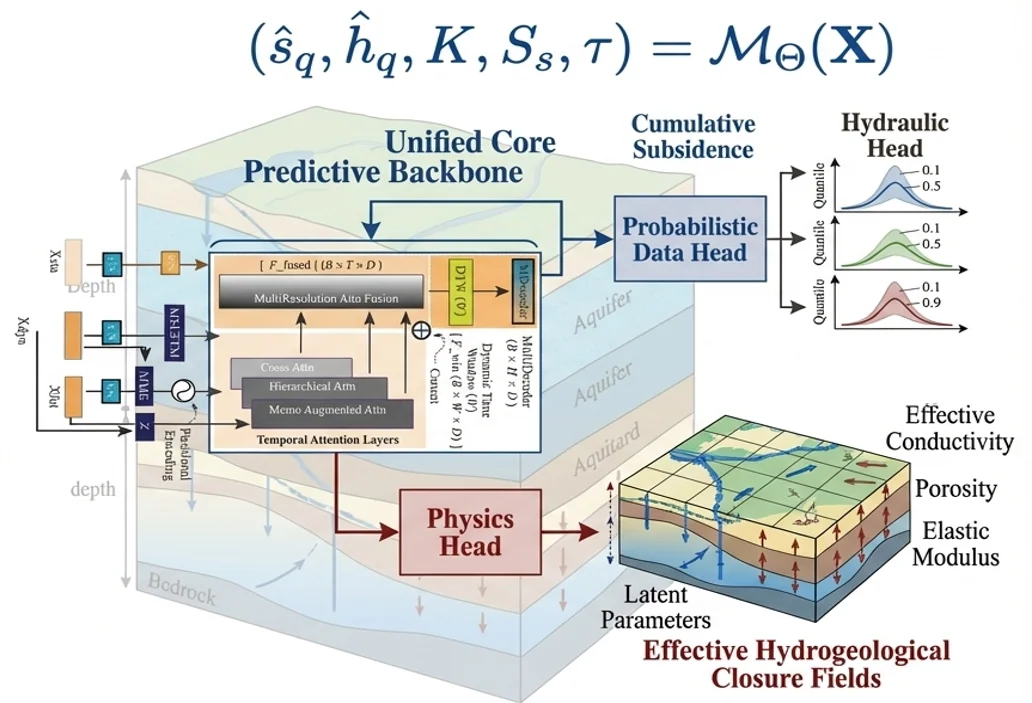
GeoPriorSubsNet — Physics-Guided Forecasting Architecture
My work introduces GeoPriorSubsNet v3, a unified encoder-decoder backbone combining multi-resolution attention fusion, a probabilistic data head (quantile outputs for cumulative subsidence and hydraulic head), and a physics head that recovers latent hydrogeological parameters — effective conductivity, porosity, and elastic modulus — without extra labels.
Hotspot Persistence & Risk Maps
GeoPriorSubsNet outputs are translated into probabilistic risk maps that identify persistent subsidence hotspots across cities. Priority clusters ranked by mean risk score let urban planners focus intervention resources where deformation concentrates — turning model outputs into actionable intelligence.
Key Discoveries
Divergent Urban Regimes
Nansha and Zhongshan exhibit fundamentally different subsidence dynamics, requiring city-specific calibration rather than one-size-fits-all models.
Physics Improves Reliability
Embedding hydrogeological constraints reduces physically implausible predictions and recovers interpretable latent parameters without extra labels.
Transferable Across Cities
Models trained in one city can be transferred to a new deployment with minimal retraining, making multi-city rollout operationally feasible.
Desktop Forecasting Suite
GeoPrior-3.0 Forecaster operationalizes GeoPriorSubsNet through a guided desktop environment — from data intake and experiment configuration to training, transfer learning, and operational forecasting — without requiring command-line skills.
Product pageMADF — Detecting Toxic Leachate with AI
Beyond locating fresh groundwater, protecting it from contamination is equally critical. This line of work applies a Multifaceted Anomaly Detection Framework (MADF) to electrical resistivity tomography (ERT) data to map and delineate toxic leachate plumes escaping from failed landfill liners.
When Landfills Fail: Toxic Leachate in the Subsurface
Anti-seepage membrane failures in landfills release toxic lixiviate — a mix of organic contaminants, heavy metals, and pathogens — into the surrounding soil and groundwater. Traditional ERT inversion locates anomalies roughly, but cannot reliably delineate excavation boundaries with the precision remediation teams need.
Majority-Vote Funnel: Three Detectors, One Ground Truth
MADF runs three unsupervised anomaly detectors — Isolation Forest (IF), One-Class SVM (OC-SVM), and Local Outlier Factor (LOF) — on resistivity features extracted from ERT sections. A majority-vote funnel fuses their binary outputs into a single confirmed anomaly mask (B_MADF), suppressing false positives from any single detector while preserving true leachate signatures.
From ERT Sections to Excavation Perimeter
Validated on two profiles (G1040 and G2030) at an active landfill site, MADF output achieved a Youden index of J = 0.095–0.052 — a substantial improvement over standard inversion (J = 0.027–0.046). The delineated leachate zone matched the confirmed membrane tear at 15 m depth, enabling engineers to define a precise excavation perimeter.
Wildfire early warning for Africa
Africa FireShield applies the same recipe — satellite data and AI — to predict and monitor wildfire risk across the continent, so communities and agencies can act before fires spread.
About Africa FireShieldKey research outcomes
What this line of work has produced so far.
- 5+
Publications
Papers in JEM, Waste Management and Geophysics on subsidence and landfill leachate, with work under review.
- 2
Cities mapped
Nansha and Zhongshan, China — multi-year InSAR time series turned into hotspot and risk-cluster maps.
- 1
Leachate detector
MADF — a majority-vote AI funnel that locates leakage zones from ERT data and guides excavation.
- 1
Patent filed
Chinese patent application (2026) for physics-constrained, closure-consistent subsidence forecasting.
Software & documentation
Open-source tools that put this research into practice.
GeoPrior-v3
Scientific Python framework for physics-guided geohazard analysis, forecasting, and risk-oriented interpretation.
GeoPrior-3.0 Forecaster
A guided desktop environment for operationalizing GeoPrior-v3 from data intake to reproducible geohazard forecasting.
Related publications
Peer-reviewed papers and preprints from this line of research.
- 2024Published
Multifaceted anomaly detection framework for leachate monitoring in landfills
Liu, R.; Jiang, S.; Ou, J.; Kouadio, K. L.*; Xiong, B.
Journal of Environmental Management
Read paper - 2024Published
Machine learning-based techniques for land subsidence simulation in an urban area
Liu, J.; Liu, W.; Allechy, F. B.; Zheng, Z.; Liu, R.; Kouadio, K. L.*
Journal of Environmental Management
Read paper - 2026Published
A low-cost method for planar localization of leakage points in closed landfills
Liu, R.; Liu, Y.; Jiang, S.; Yang, G.; Kouadio, K. L.
Waste Management
Read paper - 2026Under Review
Physics-Informed Deep Learning Reveals Divergent Urban Land Subsidence Regimes
Kouadio, K. L.; Liu, R.; Liu, Z.; Jiang, S.; Kouamelan, S.; Liu, W.; Qing, Z.; Zheng, Z.
IEEE Transactions on Geoscience and Remote Sensing
Continue exploring
Each area feeds into the others — here is where to go next.
Big Data in Earth Systems
Satellites, geophysical surveys and sensor networks produce far more data than traditional geoscience workflows can turn into insight.
Explore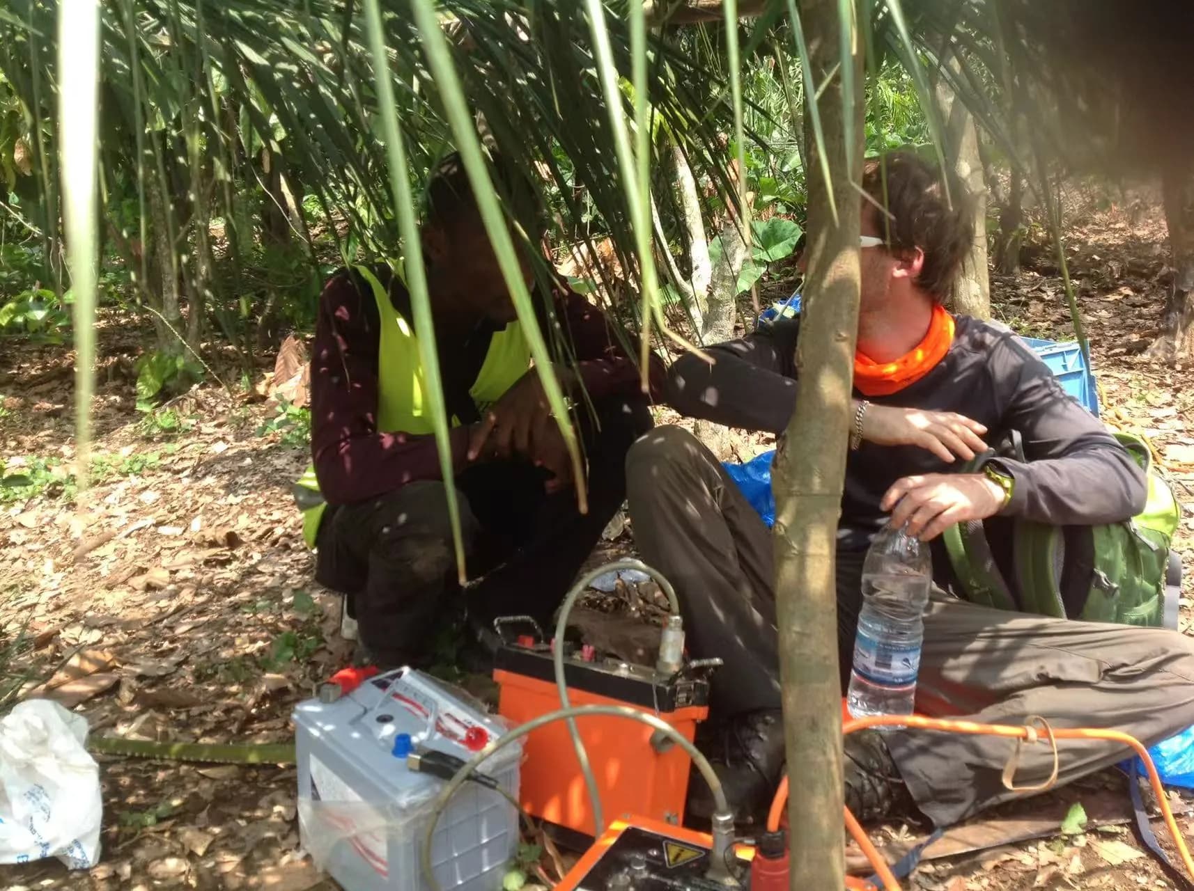
Groundwater & Mineral Exploration
Finding water and mineral resources where data are scarce remains costly and uncertain.
Explore
Uncertainty & Trustworthy Forecasting
Making reliable decisions requires a trustworthy understanding of forecast uncertainty.
Explore